 
| Sender: |
|
| Date: |
Fri, 28 Mar 2014 14:48:31 +0000 |
| Reply-To: |
|
| Subject: |
|
| From: |
|
| MIME-Version: |
1.0 |
| In-Reply-To: |
|
| Content-Type: |
multipart/related;
boundary="_011_186573D246FA4F4794FF19C38EB27AD0C250B563NMSBSnmdevcomlo_";
type="multipart/alternative" |
| Comments: |
|
| Parts/Attachments: |
|
|
Nice touch, maybe there is a silver lining here for us after the storm in Washington State.
Ken
From: Maine GeoNews [mailto:[log in to unmask]] On Behalf Of Young, Joseph
Sent: Friday, March 28, 2014 10:30 AM
To: [log in to unmask]
Subject: OSA Washington Mudslide
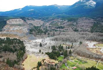
THIS
[http://www.blogcdn.com/slideshows/images/slides/250/119/7/S2501197/slug/l/480309413-1.jpg]
could happen here.
In fact it has several times along Maine's coast and inland rivers. The 3" quality image lets us know, there must be a reason why the development has progressed the way it did.
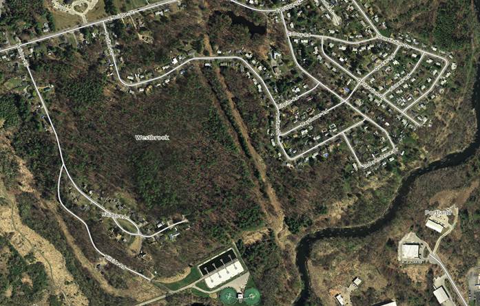
[cid:image002.jpg@01CF4A73.41F148A0]
The LiDAR image below shows why! An old landslide occurred in Westbrook and we have developed along the banks, the banks of the river that caused the original slide, and on the lowlands next to the river.
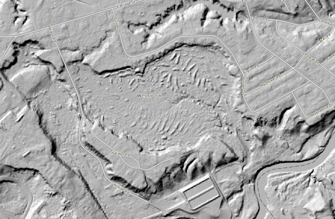
This is just one of the many uses of LiDAR that shows its value. Notice the little hummocks in the center of the slide area and the drainage path created by runoff from the site.
[cid:image003.png@01CF4A73.41F148A0][cid:image005.png@01CF4A73.41F148A0][cid:image006.jpg@01CF4A73.41F148A0]
And this is what we can see with the old 10-meter USGS topographic data.
[cid:image007.jpg@01CF4A73.41F148A0]
The Maine Geological survey has done studies of landslides in Maine and you can find more information HERE<http://www.maine.gov/dacf/mgs/hazards/landslides/facts/nov10.pdf>
For more information, contact the Maine Geological Survey 207- 287-7179
Joseph Young
Executive Director
Maine GeoLibrary
SHS 145
51 Commerce Drive
Augusta, Maine 04333- 145
VP 207-624-2664
FAX 207-287-1131
[MaineGeoLibrary_Web_banner_JY]
----------------------------------------------------------------------- This list Maine GeoNews (GEOLIBRARY-L) is an unmoderated discussion list for all Maine GIS Users. If you no longer wish to receive e-mail from this list, you can remove your name and email address yourself at the this web address:
http://lists.maine.edu/cgi/wa?SUBED1=geolibrary-l&A=1
Or,you may also request that your name be removed by sending email to:
[log in to unmask]<mailto:[log in to unmask]>
-----------------------------------------------------------------------
This list Maine GeoNews (GEOLIBRARY-L) is an unmoderated discussion list for all Maine GIS Users. If you no longer wish to receive e-mail from this list, you can remove your name and email address yourself at the this web address:
http://lists.maine.edu/cgi/wa?SUBED1=geolibrary-l&A=1
Or,you may also request that your name be removed by sending email to:
[log in to unmask]
|
|
|


