 
| Subject: | |
| From: | |
| Reply To: | Smith, Michael |
| Date: | Tue, 9 Apr 2013 17:59:05 +0000 |
| Content-Type: | multipart/related |
| Parts/Attachments: |
|
|
The Maine Office of GIS is pleased to announce the availability of 2-meter resolution lidar products for the entire area of Maine that currently has lidar data. These products are now available to the public on the MEGIS data catalog and for state employees in the enterprise SDE database.
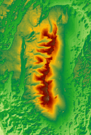
1) 2-meter digital elevation models from lidar. These DEMs are mosaicked from the different lidar projects Maine has and are accurate to RMSEz 15cm or better. The web map service (WMS) displays the elevation values using a linear stretch against a black-white color ramp, for more functionality you can download the tiles from the MEGIS orthoimagery viewer. For state employees this is also in the GISRASTER SDE database, MEGIS.MEDEM2.
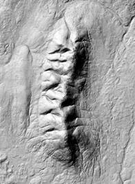
2) 2-meter hillshade model from lidar (built from MEDEM2). This is a simple hillshade model built from MEDEM2 using a default azimuth of 315 and a default altitude of 45. Z-factor is set to 3 (exaggerates heights 3 times their normal size). This is available as WMS and as tiles that can be downloaded from the MEGIS orthoimagery viewer. Not available in SDE.
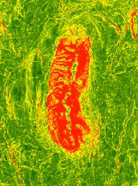
3) 2-meter slope model from lidar (built from MEDEM2). This shows slope (% slope) based on MEDEM2. The WMS displays slope using a curved stretch against a black-white color ramp, for more functionality you can download the tiles from the MEGIS orthoimagery viewer. For state employees this is also in the GISRASTER SDE database, MEGIS.MEDEM2_SLOPE
All elevations are based on NAVD88, thus you will note that much of the coast does not go down to "zero". That is because in some cases lidar was collected at a tidal level which was higher than NAVD88's "zero".
[cid:image002.png@01CE352A.054B90E0] [cid:image007.jpg@01CE352A.65AF5110] [cid:image008.jpg@01CE352A.65AF5110]
Mars Hill, ME. DEM (left) hillshade (center) and slope model (right). Red = higher slope.
Coming very soon - 2' contours from the same data, date index indicating date of lidar collection...
===============================
Michael Smith MS GISP
State GIS Manager, Maine Office of GIS
State of Maine, Office of Information Technology
michael.smith _at_ maine.gov 207-215-5530
Board Member, Maine GeoLibrary
Education Chair, Maine GIS Users Group
State Rep, National States Geographic Information Council
[cid:image001.jpg@01CE3528.360BA5A0]
State House Station 145
51 Commerce Drive
Augusta, ME 04333-0145
69o 47' 58.9"W 44o 21' 54.8"N
-----------------------------------------------------------------------
This list Maine GeoNews (GEOLIBRARY-L) is an unmoderated discussion list for all Maine GIS Users. If you no longer wish to receive e-mail from this list, you can remove your name and email address yourself at the this web address:
http://lists.maine.edu/cgi/wa?SUBED1=geolibrary-l&A=1
Or,you may also request that your name be removed by sending email to:
[log in to unmask]
|
|
|


