 
| Subject: | |
| From: | |
| Reply To: | V. Kelly Bellis |
| Date: | Thu, 5 Oct 2023 07:40:59 -0400 |
| Content-Type: | multipart/alternative |
| Parts/Attachments: |
|
|
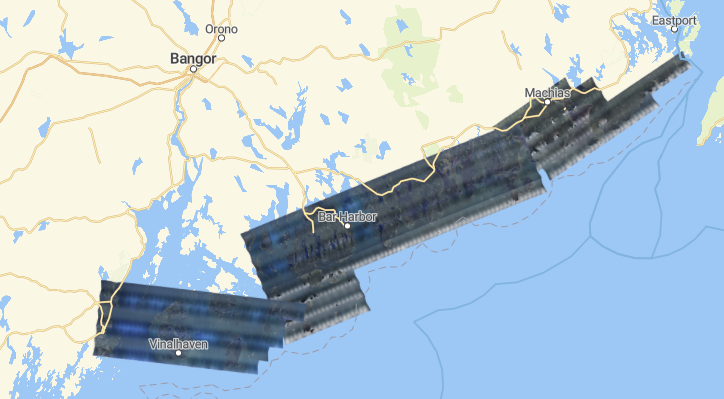
    NGS Collects Emergency Response Imagery of Hurricane Lee


      October 2, 2023

NGS collected aerial images in the aftermath of Hurricane Lee
<https://oceanservice.noaa.gov/news/sep23/ngs-storm-imagery-lee.html>.
The crew flew over more than 4,566 square kilometers and collected 1,482
images in 9.2 hours. The imagery was collected in specific,
NOAA-identified, and Federal Emergency Management Agency-assigned areas
in coordination with other federal agencies and impacted states. Aerial
imagery is a cost-effective way to better understand both property and
environmental damage. The imagery is used to determine the extent of
flood and storm damage to major ports and waterways, coastlines,
critical infrastructure, and coastal communities. NOAA's aerial imagery
also assists with safe navigation. NGS delivers the imagery through this
website <https://storms.ngs.noaa.gov/>, which supports both the general
public’s needs and advanced applications.

For more information, contact: Mike Aslaksen
<https://geodesy.noaa.gov/cgi-bin/redirectNOAA.prl?u=Mike.Aslaksen>

--
Untitled Document
logo 	V. Kelly Bellis
Maine PLS 2099
17 Union Street
Ellsworth, ME 04605
Viewed from above
<https://www.360cities.net/image/union-river-bay-to-graham-lake>

-----------------------------------------------------------------------
This list Maine GeoNews (GEOLIBRARY-L) is an unmoderated discussion list for all Maine GIS Users. If you no longer wish to receive e-mail from this list, you can remove your name and email address yourself at the this web address:

https://lists.maine.edu/cgi-bin/wa?SUBED1=GEOLIBRARY-L&A=1

Or, you may also request that your name be removed by sending email to:

[log in to unmask]
|
|
|


