7.5' USGS Topos & NOAA Nautical Charts WMS Services URLs:
http://mapserver.maine.gov/wms/mapserv.exe?map=c:/wms/topos.map&
Mike - I'm with Gretchen; this is very good news, thanks for all of your
efforts!!
The now available LiDAR-based 2' contours from MeGIS will be greatly
appreciated by these communities.
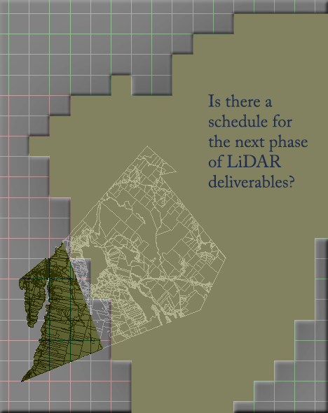
Some communities; for example, Orland (shown below) may begin to wonder:
Is there a schedule for filling in the blanks?
V. Kelly Bellis, PLS 2099 - 17 Union Street - Ellsworth, ME 04605
[log in to unmask] <mailto:[log in to unmask]> - 207.667.6912 -
Horizon Surveying Co.
On 5/23/2013 4:51 PM, Gretchen Heldmann wrote:
> I don't want to be too bold, but I think I probably speak for more
> than just myself when I say:
> THANK YOU!
>
> ~G
>
> __________________________
> *Gretchen Heldmann, GISP*
> GIS/IT Specialist, Town of Hampden
> Office Hours: Mon.-Thurs. 7:30am-6pm
> 106 Western Avenue
> Hampden, ME 04444
> Phone: (207)862.4500 x142
> http://www.hampdenmaine.gov/
> *!NEW!* Aerial Imagery for Maine!
> http://www.maine.gov/geolib/orthophotography.htm
>
>
>
>
> On Thu, May 23, 2013 at 4:35 PM, Smith, Michael
> <[log in to unmask] <mailto:[log in to unmask]>> wrote:
>
> Hi everyone,
>
> The Maine Office of GIS is pleased to announce the release of 2’
> contours for lidar areas in Maine. These data are now available
> on our data catalog, or for our state employees, via our
> enterprise geodatbase (layer GISVIEW.MEGIS.Contours_2ft). Please
> read the metadata before asking questions about the contours. The
> contours are tiled out by town, and currently are available for
> all or portions of 266 towns and townships. As we continue to get
> more lidar data we will update the collection. *Due to the sheer
> size of these data, we will not make them available in Google
> Earth KMZ format.* All together they number just shy of 17
> million line segments and even when zipped take up 11.5GB of disk
> space.
>
> Also loaded last week, but not sure I announced it, we have made
> available a collection of historic NOAA charts from the late
> 1800s. These are available as a web mapping service. This is in
> the ‘topos’ WMS and is listed on the data catalog. The purpose of
> this is just for historical reference, especially as many coastal
> buildings or roads are carefully mapped on these charts.
>
> Happy contour mapping!
>
> ===============================
> *Michael Smith MS GISP*
> State GIS Manager, Maine Office of GIS
> State of Maine, Office of Information Technology
> /michael.smith _at_ maine.gov <http://maine.gov>/ 207-215-5530
> <tel:207-215-5530>
>
> Board Member, Maine GeoLibrary
> Education Chair, Maine GIS Users Group
> State Rep, National States Geographic Information Council
>
>
> State House Station 145
> 51 Commerce Drive
> Augusta, ME 04333-0145
> 69^o 47' 58.9"W 44^o 21' 54.8"N
>
> -----------------------------------------------------------------------
> This list Maine GeoNews (GEOLIBRARY-L) is an unmoderated
> discussion list for all Maine GIS Users. If you no longer wish to
> receive e-mail from this list, you can remove your name and email
> address yourself at the this web address:
>
> http://lists.maine.edu/cgi/wa?SUBED1=geolibrary-l&A=1
> <http://lists.maine.edu/cgi/wa?SUBED1=geolibrary-l&A=1>
>
> Or,you may also request that your name be removed by sending email
> to:
>
> [log in to unmask]
> <mailto:[log in to unmask]>
>
>
> ----------------------------------------------------------------------- This
> list Maine GeoNews (GEOLIBRARY-L) is an unmoderated discussion list
> for all Maine GIS Users. If you no longer wish to receive e-mail from
> this list, you can remove your name and email address yourself at the
> this web address:
>
> http://lists.maine.edu/cgi/wa?SUBED1=geolibrary-l&A=1
>
> Or,you may also request that your name be removed by sending email to:
>
> [log in to unmask]
>
-----------------------------------------------------------------------
This list Maine GeoNews (GEOLIBRARY-L) is an unmoderated discussion list for all Maine GIS Users. If you no longer wish to receive e-mail from this list, you can remove your name and email address yourself at the this web address:
http://lists.maine.edu/cgi/wa?SUBED1=geolibrary-l&A=1
Or,you may also request that your name be removed by sending email to:
[log in to unmask]
|


