| Subject: | NASA Earthdata Webinar 10/4: Topic- Monitoring Earth’s Ionosphere for Natural Hazards in Near Real-Time |
|---|---|
| Date: | Tue, 26 Sep 2023 16:26:39 +0000 |
| From: | Brennan, Jennifer L. (GSFC-423.0)[ADNET SYSTEMS INC] <[log in to unmask]> |
You are invited to the NASA Earthdata webinar, “GUARDIAN: Monitoring Earth’s Ionosphere for Natural Hazards in Near Real-Time” to be held Wednesday, October 4, 2023, at 2:00 PM EDT (UTC/GMT-4).
*Please excuse any duplicates for those of you on the original invite list*
Webinar POC: Jennifer Brennan, Host, NASA ESDIS Communications Lead
Email: [log in to unmask]
Registration: https://www.earthdata.nasa.gov/learn/webinars-and-tutorials/webinar-guardian-cddis-04-Oct-2023
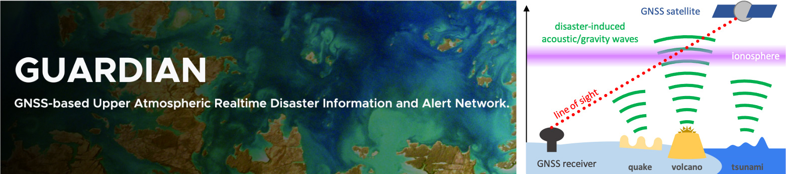
Description: Several natural phenomena on Earth and in space, such as tsunamis, volcanic eruptions, earthquakes, and geomagnetic and solar storms leave a readily-detectable signature in the Earth's ionosphere. Monitoring the ionosphere in real-time can therefore greatly enhance our early warning systems for these events. Traditionally, the ionospheric response to these sources has been studied several days to weeks after the event occurs. For the ionosphere to be used as a medium for hazard warning, it must be monitored in near-real-time with analyses provided in a timelier fashion.
The GNSS-based Upper Atmospheric Realtime Disaster Information and Alert Network (GUARDIAN) is a state-of-the-art near-real-time monitor designed to provide estimates of the ionospheric line of sight total electron content (TEC) from L-band radio-frequency signals transmitted by the Global Navigation Satellite System (GNSS) satellites. We combine, clean, and filter phase data to generate TEC time-series for multiple constellations from nearly 90 stations around the Pacific Ring of Fire with an approximate latency of 3 minutes. GUARDIAN builds on JPL's Global Differential GPS (GDGPS) capability and the International GNSS Service (IGS) network, which aggregate GNSS phase data from a network of real-time worldwide stations.
In this presentation, we will discuss the architecture of the GUARDIAN system, highlight several examples and use cases, and share future plans for its development, with the hopes of enhancing existing hazard warning frameworks to safeguard communities around the world.
Speaker:
Dr. Siddharth Krishnamoorthy, Research Technologist, Ionospheric and Atmospheric Remote Sensing Group, NASA’s Jet Propulsion Laboratory (JPL), California Institute of Technology (Caltech)
Dr. Krishnamoorthy is a Research Technologist at the Ionospheric and Atmospheric Remote Sensing group at NASA’s Jet Propulsion Laboratory. He holds a PhD in Aeronautics and Astronautics from Stanford University and a Masters in Physics from the Indian Institute of Technology Delhi, India. Siddharth is developing remote sensing methods for Earth and planetary applications. He serves as a technical lead on the GUARDIAN project and also supports Deep Space Network operations.
Q & A Panelists:
Dr. Léo Martire, Research Technologist, Ionospheric and Atmospheric Remote Sensing Group, NASA JPL, Caltech
Dr. Léo Martire, a Research Technologist at JPL and the Deputy Director of the International GNSS Service's Central Bureau, holds a PhD with honors in Astrophysics, Space Science, and Planetary Science. Their expertise bridges applied mathematics, numerical modeling, and geophysical acoustics, with a focus on the propagation of mechanical waves from planetary bodies’ near-interior to their ionosphere's outer bounds. In addition to their scientific and technical contributions, Dr. Martire also chairs an international Task Force on Applications of GNSS for Disaster Risk Reduction, operating under the United Nations' Office for Outer Space Affairs.
Dr. Attila Komjathy, Group Supervisor, Near Earth Tracking Systems Group, NASA JPL, Caltech
Attila Komjathy is a JPL Principal and Supervisor of the Near Earth Tracking Systems Group at the NASA Jet Propulsion Laboratory. He received his Ph.D. from the Department of Geodesy and Geomatics Engineering of the University of New Brunswick, Canada. He has been active in space research and GNSS applications for 30 years specializing in various aspects of GNSS ionospheric and atmospheric remote sensing techniques. He is a Fellow of the U.S. Institute of Navigation and served Commission Chair at USNC-USRI. He works as an Associate Editor for AGU’s Radio Science.
For more information and to register
Please do not hesitate to reach out to me with any questions. Also, feel free to share this invite with your colleagues.
Best Regards,
Jennifer
Brennan, NASA
Earthdata
Webinar Host,
ESDIS
Communications
Lead
https://lists.maine.edu/cgi-bin/wa?SUBED1=GEOLIBRARY-L&A=1
Or, you may also request that your name be removed by sending email to: